| Magnitude | 6.3 |
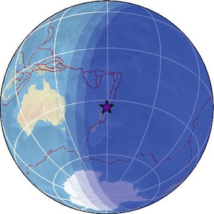
| Region | SOUTH OF KERMADEC ISLANDS |
| Date time | 2026-08-05 07:43:24.2 UTC |
| Location | -33.813 ; 179.475 |
| Depth | 197 km |
| Distance | 525 km NNE of Tauranga, New Zealand / pop: 110,000 / local time: 19:43:24.2 2026-08-05 435 km N of Hicks Bay, New Zealand / pop: 1,300 / local time: 19:43:24.2 2026-08-05 |
Source parameters reviewed by a seismologist
All data providers for this event:
Geoscience Australia, Canberra, ACT, Australia -- Canberra, Australia (AUST)British Geological Survey -- Edinburgh, United Kingdom (BGS)
French Polynesian Tsunami Warning Center - CEA -- Papeete, Polynesie Francaise - Tahiti (CPPT)
Badan Meteorologi, Klimatologi dan Geofisika -- Jakarta, Indonesia (BMKG)
Institute of Geophysics of the Czech Academy of Sciences -- Prague, Czech Republic (GFU)
GeoForschungsZentrum (GFZ) -- Potsdam, Germany (GFZ)
Geonet, GNS science -- Lower Hutt, New Zealand (GNS)
Geophysical Survey of the Russian Academy of Sciences -- Obninsk, Russia (GSRAS)
Instituto Portugues do Mar e da Atmosfera -- Lisbon, Portugal (IPMA)
Instituto Nazionale di Geofisica e Vulcanologia -- Rome, Italy (INGV) -- DOI: https://terremoti.ingv.it/en/iside
Kandilli Observatory and Earthquake Research Institute -- Istanbul, Türkiye (KOERI)
Instituto Geografico Nacional -- Madrid, Spain (IGN)
Ukrainian NDC, Main Center of Special Monitoring -- Kyiv, Ukraine (MCSM)
National Earthquake Information Center, U.S. Geological Survey -- Golden, United States (NEIC)
EMSC -- Arpajon, France (SC4)
Further information can be found at:
GeoForschungsZentrum (GFZ) -- Potsdam, Germany (GFZ)Geonet, GNS science -- Lower Hutt, New Zealand (GNS)
National Earthquake Information Center, U.S. Geological Survey -- Golden, United States (NEIC)