| Magnitude | 5.1 |
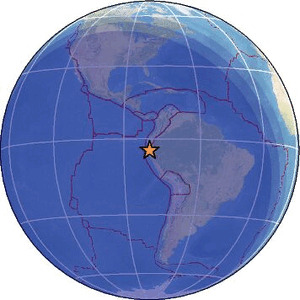
| Region | PERU-ECUADOR BORDER REGION |
| Date time | 2026-06-13 06:35:39.6 UTC |
| Location | -4.516 ; -79.999 |
| Depth | 72 km |
| Distance | 87 km NE of Sullana, Peru / pop: 160,000 / local time: 01:35:39.6 2026-06-13 16 km SSW of Macará, Ecuador / pop: 13,000 / local time: 01:35:39.6 2026-06-13 |
Source parameters provided by:
National Earthquake Information Center, U.S. Geological Survey -- Golden, United States (NEIC)
All data providers for this event:
GeoForschungsZentrum (GFZ) -- Potsdam, Germany (GFZ)Kandilli Observatory and Earthquake Research Institute -- Istanbul, Türkiye (KOERI)
National Earthquake Information Center, U.S. Geological Survey -- Golden, United States (NEIC)
Escuela Politecnica Nacional, Quito, Ecuador -- Quito, Ecuador (QUI)
EMSC -- Arpajon, France (SC4)
Further information can be found at:
Instituto Geofisico del Peru -- Lima, Peru (LIM)National Earthquake Information Center, U.S. Geological Survey -- Golden, United States (NEIC)
Escuela Politecnica Nacional, Quito, Ecuador -- Quito, Ecuador (QUI)
GeoForschungsZentrum (GFZ) -- Potsdam, Germany (GFZ)