| Magnitude | 5.5 |
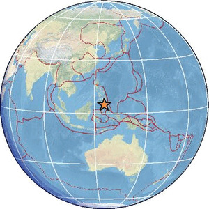
| Region | KEPULAUAN SANGIHE, INDONESIA |
| Date time | 2026-06-11 01:56:14.6 UTC |
| Location | 4.878 ; 125.436 |
| Depth | 50 km |
| Distance | 140 km SSE of General Santos, Philippines / pop: 679,000 / local time: 09:56:14.6 2026-06-11 59 km S of Sarangani, Philippines / pop: 7,500 / local time: 09:56:14.6 2026-06-11 |
Source parameters provided by:
National Earthquake Information Center, U.S. Geological Survey -- Golden, United States (NEIC)
All data providers for this event:
British Geological Survey -- Edinburgh, United Kingdom (BGS)Badan Meteorologi, Klimatologi dan Geofisika -- Jakarta, Indonesia (BMKG)
GeoForschungsZentrum (GFZ) -- Potsdam, Germany (GFZ)
Kandilli Observatory and Earthquake Research Institute -- Istanbul, Türkiye (KOERI)
National Earthquake Information Center, U.S. Geological Survey -- Golden, United States (NEIC)
EMSC -- Arpajon, France (SC4)
Further information can be found at:
National Earthquake Information Center, U.S. Geological Survey -- Golden, United States (NEIC)Philippine Inst. of Volcanology and Seismology, Quezon City, Philippines -- Manila, Philippines (PIVS)
Badan Meteorologi, Klimatologi dan Geofisika -- Jakarta, Indonesia (BMKG)
GeoForschungsZentrum (GFZ) -- Potsdam, Germany (GFZ)