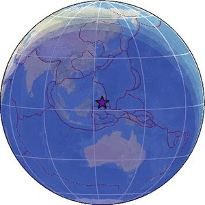
| Magnitude | 3.4 |
| Region | CELEBES SEA |
| Date time | 2026-06-02 16:07:43.0 UTC |
| Location | 4.180 ; 124.830 |
| Depth | 293 km |
| Distance | 218 km S of General Santos, Philippines / pop: 679,000 / local time: 00:07:43.0 2026-06-03 153 km SSW of Sarangani, Philippines / pop: 7,500 / local time: 00:07:43.0 2026-06-03 |
Source parameters provided by:
Badan Meteorologi, Klimatologi dan Geofisika -- Jakarta, Indonesia (BMKG)
All data providers for this event:
Badan Meteorologi, Klimatologi dan Geofisika -- Jakarta, Indonesia (BMKG)Philippine Inst. of Volcanology and Seismology, Quezon City, Philippines -- Manila, Philippines (PIVS)
Further information can be found at:
National Earthquake Information Center, U.S. Geological Survey -- Golden, United States (NEIC)Philippine Inst. of Volcanology and Seismology, Quezon City, Philippines -- Manila, Philippines (PIVS)
GeoForschungsZentrum (GFZ) -- Potsdam, Germany (GFZ)
Badan Meteorologi, Klimatologi dan Geofisika -- Jakarta, Indonesia (BMKG)