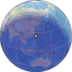
| Magnitude | 4.6 |
| Region | SOUTHWESTERN RYUKYU ISL., JAPAN |
| Date time | 2026-05-09 16:18:52.0 UTC |
| Location | 24.539 ; 123.771 |
| Depth | 35 km |
| Distance | 215 km E of Keelung, Taiwan / pop: 397,000 / local time: 00:18:52.0 2026-05-10 45 km WNW of Ishigaki, Japan / pop: 44,800 / local time: 01:18:52.0 2026-05-10 |
Source parameters provided by:
National Earthquake Information Center, U.S. Geological Survey -- Golden, United States (NEIC)
All data providers for this event:
National Institute for Earth Physics -- Bucharest, Romania (NIEP)GeoForschungsZentrum (GFZ) -- Potsdam, Germany (GFZ)
Geophysical Survey of the Russian Academy of Sciences -- Obninsk, Russia (GSRAS)
Japan Meteorological Agency Seismic Network -- Tokyo, Japan (JMA)
Malaysian Meteorological Department -- Kuala Lumpur, Malaysia (MET)
National Earthquake Information Center, U.S. Geological Survey -- Golden, United States (NEIC)
EMSC -- Arpajon, France (SC4)
Further information can be found at:
GeoForschungsZentrum (GFZ) -- Potsdam, Germany (GFZ)Japan Meteorological Agency Seismic Network -- Tokyo, Japan (JMA)
National Earthquake Information Center, U.S. Geological Survey -- Golden, United States (NEIC)