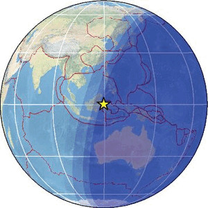
| Magnitude | 4.4 |
| Region | MINAHASA, SULAWESI, INDONESIA |
| Date time | 2026-05-02 11:11:06.0 UTC |
| Location | 0.280 ; 119.480 |
| Depth | 14 km |
| Distance | 273 km ENE of Samarinda, Indonesia / pop: 355,000 / local time: 19:11:06.0 2026-05-02 139 km NNW of Palu, Indonesia / pop: 282,000 / local time: 19:11:06.0 2026-05-02 |
Source parameters provided by:
Badan Meteorologi, Klimatologi dan Geofisika -- Jakarta, Indonesia (BMKG)
All data providers for this event:
Badan Meteorologi, Klimatologi dan Geofisika -- Jakarta, Indonesia (BMKG)Malaysian Meteorological Department -- Kuala Lumpur, Malaysia (MET)
Further information can be found at:
GeoForschungsZentrum (GFZ) -- Potsdam, Germany (GFZ)National Earthquake Information Center, U.S. Geological Survey -- Golden, United States (NEIC)
Badan Meteorologi, Klimatologi dan Geofisika -- Jakarta, Indonesia (BMKG)
Philippine Inst. of Volcanology and Seismology, Quezon City, Philippines -- Manila, Philippines (PIVS)