| Magnitude | 4.8 |
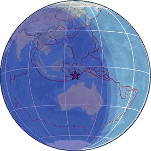
| Region | KEPULAUAN BARAT DAYA, INDONESIA |
| Date time | 2026-05-01 18:52:47.4 UTC |
| Location | -7.379 ; 128.392 |
| Depth | 172 km |
| Distance | 337 km NE of Dili, Timor Leste / pop: 150,000 / local time: 03:52:47.4 2026-05-02 199 km NE of Lospalos, Timor Leste / pop: 17,100 / local time: 03:52:47.4 2026-05-02 |
Source parameters provided by:
National Earthquake Information Center, U.S. Geological Survey -- Golden, United States (NEIC)
All data providers for this event:
Badan Meteorologi, Klimatologi dan Geofisika -- Jakarta, Indonesia (BMKG)GeoForschungsZentrum (GFZ) -- Potsdam, Germany (GFZ)
Malaysian Meteorological Department -- Kuala Lumpur, Malaysia (MET)
National Earthquake Information Center, U.S. Geological Survey -- Golden, United States (NEIC)
EMSC -- Arpajon, France (SC4)
Further information can be found at:
GeoForschungsZentrum (GFZ) -- Potsdam, Germany (GFZ)Badan Meteorologi, Klimatologi dan Geofisika -- Jakarta, Indonesia (BMKG)
National Earthquake Information Center, U.S. Geological Survey -- Golden, United States (NEIC)