| Magnitude | 3.2 |
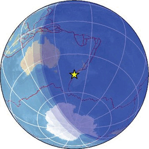
| Region | OFF W. COAST OF S. ISLAND, N.Z. |
| Date time | 2026-04-26 09:24:05.2 UTC |
| Location | -46.378 ; 166.084 |
| Depth | 12 km |
| Distance | 345 km WSW of Dunedin, New Zealand / pop: 114,000 / local time: 21:24:05.2 2026-04-26 148 km WSW of Riverton, New Zealand / pop: 1,400 / local time: 21:24:05.2 2026-04-26 |
Source parameters provided by:
Geonet, GNS science -- Lower Hutt, New Zealand (GNS)
All data providers for this event:
Geonet, GNS science -- Lower Hutt, New Zealand (GNS)Further information can be found at:
National Earthquake Information Center, U.S. Geological Survey -- Golden, United States (NEIC)Geonet, GNS science -- Lower Hutt, New Zealand (GNS)
GeoForschungsZentrum (GFZ) -- Potsdam, Germany (GFZ)