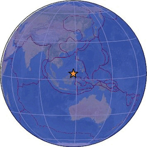
| Magnitude | 2.6 |
| Region | SABAH-KALIMANTAN BORDER REGION |
| Date time | 2026-03-22 15:41:48.8 UTC |
| Location | 4.870 ; 117.499 |
| Depth | 71 km |
| Distance | 128 km SSW of Sandakan, Malaysia / pop: 392,000 / local time: 23:41:48.8 2026-03-22 82 km NW of Tawau, Malaysia / pop: 306,000 / local time: 23:41:48.8 2026-03-22 |
Source parameters provided by:
Malaysian Meteorological Department -- Kuala Lumpur, Malaysia (MET)
All data providers for this event:
Malaysian Meteorological Department -- Kuala Lumpur, Malaysia (MET)Further information can be found at:
GeoForschungsZentrum (GFZ) -- Potsdam, Germany (GFZ)Philippine Inst. of Volcanology and Seismology, Quezon City, Philippines -- Manila, Philippines (PIVS)
National Earthquake Information Center, U.S. Geological Survey -- Golden, United States (NEIC)
Badan Meteorologi, Klimatologi dan Geofisika -- Jakarta, Indonesia (BMKG)
Malaysian Meteorological Department -- Kuala Lumpur, Malaysia (MET)