| Magnitude | 5.1 |
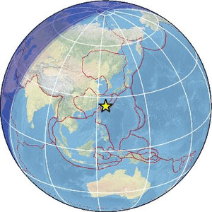
| Region | SOUTHWESTERN RYUKYU ISL., JAPAN |
| Date time | 2026-02-28 01:49:19.8 UTC |
| Location | 25.186 ; 125.035 |
| Depth | 10 km |
| Distance | 289 km SW of Naha, Japan / pop: 300,000 / local time: 10:49:19.8 2026-02-28 50 km NW of Hirara, Japan / pop: 34,300 / local time: 10:49:19.8 2026-02-28 |
Source parameters provided by:
National Earthquake Information Center, U.S. Geological Survey -- Golden, United States (NEIC)
All data providers for this event:
HUN-REN EPSS Kövesligethy Radó Seismological Observato -- Budapest, Hungary (BUD)GeoForschungsZentrum (GFZ) -- Potsdam, Germany (GFZ)
Japan Meteorological Agency Seismic Network -- Tokyo, Japan (JMA)
Kandilli Observatory and Earthquake Research Institute -- Istanbul, Turkey (KOERI)
Malaysian Meteorological Department -- Kuala Lumpur, Malaysia (MET)
National Earthquake Information Center, U.S. Geological Survey -- Golden, United States (NEIC)
The research institute NORSAR -- Kjeller, Norway (NORSAR)
EMSC -- Arpajon, France (SC4)
Further information can be found at:
Japan Meteorological Agency Seismic Network -- Tokyo, Japan (JMA)National Earthquake Information Center, U.S. Geological Survey -- Golden, United States (NEIC)
GeoForschungsZentrum (GFZ) -- Potsdam, Germany (GFZ)