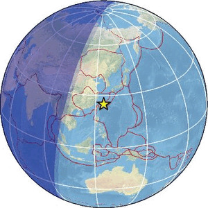
| Magnitude | 4.7 |
| Region | SOUTHWESTERN RYUKYU ISL., JAPAN |
| Date time | 2026-02-26 23:06:31.0 UTC |
| Location | 25.201 ; 125.017 |
| Depth | 10 km |
| Distance | 290 km SW of Naha, Japan / pop: 300,000 / local time: 08:06:31.0 2026-02-27 53 km NW of Hirara, Japan / pop: 34,300 / local time: 08:06:31.0 2026-02-27 |
Source parameters provided by:
National Earthquake Information Center, U.S. Geological Survey -- Golden, United States (NEIC)
All data providers for this event:
GeoForschungsZentrum (GFZ) -- Potsdam, Germany (GFZ)Japan Meteorological Agency Seismic Network -- Tokyo, Japan (JMA)
Malaysian Meteorological Department -- Kuala Lumpur, Malaysia (MET)
National Earthquake Information Center, U.S. Geological Survey -- Golden, United States (NEIC)
Further information can be found at:
Japan Meteorological Agency Seismic Network -- Tokyo, Japan (JMA)National Earthquake Information Center, U.S. Geological Survey -- Golden, United States (NEIC)
GeoForschungsZentrum (GFZ) -- Potsdam, Germany (GFZ)