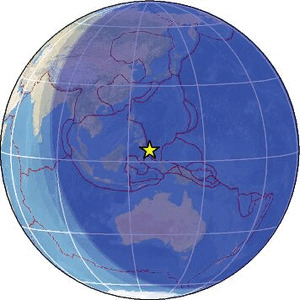
| Magnitude | 4.6 |
| Region | NORTH OF HALMAHERA, INDONESIA |
| Date time | 2026-02-13 13:12:19.0 UTC |
| Location | 4.403 ; 128.253 |
| Depth | 6 km |
| Distance | 362 km SE of Mati, Philippines / pop: 105,000 / local time: 21:12:19.0 2026-02-13 299 km N of Tobelo, Indonesia / pop: 10,000 / local time: 22:12:19.0 2026-02-13 |
Source parameters reviewed by a seismologist
All data providers for this event:
Badan Meteorologi, Klimatologi dan Geofisika -- Jakarta, Indonesia (BMKG)GeoForschungsZentrum (GFZ) -- Potsdam, Germany (GFZ)
Geophysical Survey of the Russian Academy of Sciences -- Obninsk, Russia (GSRAS)
Philippine Inst. of Volcanology and Seismology, Quezon City, Philippines -- Manila, Philippines (PIVS)
Further information can be found at:
GeoForschungsZentrum (GFZ) -- Potsdam, Germany (GFZ)Badan Meteorologi, Klimatologi dan Geofisika -- Jakarta, Indonesia (BMKG)
National Earthquake Information Center, U.S. Geological Survey -- Golden, United States (NEIC)
Philippine Inst. of Volcanology and Seismology, Quezon City, Philippines -- Manila, Philippines (PIVS)