| Magnitude | 4.6 |
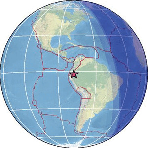
| Region | PERU-ECUADOR BORDER REGION |
| Date time | 2026-02-12 21:52:58.3 UTC |
| Location | -2.412 ; -77.627 |
| Depth | 119 km |
| Distance | 140 km ESE of Riobamba, Ecuador / pop: 124,000 / local time: 16:52:58.3 2026-02-12 55 km E of Macas, Ecuador / pop: 23,600 / local time: 16:52:58.3 2026-02-12 |
Source parameters reviewed by a seismologist
All data providers for this event:
GeoForschungsZentrum (GFZ) -- Potsdam, Germany (GFZ)Instituto Geofisico del Peru -- Lima, Peru (LIM)
National Earthquake Information Center, U.S. Geological Survey -- Golden, United States (NEIC)
Escuela Politecnica Nacional, Quito, Ecuador -- Quito, Ecuador (QUI)
EMSC -- Arpajon, France (SC4)
Further information can be found at:
GeoForschungsZentrum (GFZ) -- Potsdam, Germany (GFZ)Instituto Geofisico del Peru -- Lima, Peru (LIM)
Escuela Politecnica Nacional, Quito, Ecuador -- Quito, Ecuador (QUI)
National Earthquake Information Center, U.S. Geological Survey -- Golden, United States (NEIC)