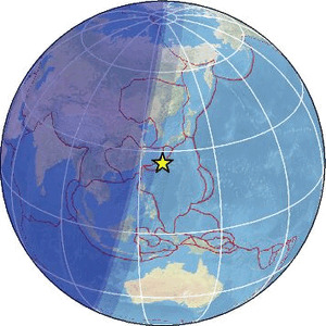
| Magnitude | 5.5 |
| Region | RYUKYU ISLANDS, JAPAN |
| Date time | 2026-02-12 21:48:13.2 UTC |
| Location | 25.765 ; 128.617 |
| Depth | 10 km |
| Distance | 672 km S of Kagoshima, Japan / pop: 555,000 / local time: 06:48:13.2 2026-02-13 106 km ESE of Naha, Japan / pop: 300,000 / local time: 06:48:13.2 2026-02-13 |
Source parameters provided by:
National Earthquake Information Center, U.S. Geological Survey -- Golden, United States (NEIC)
All data providers for this event:
British Geological Survey -- Edinburgh, United Kingdom (BGS)Badan Meteorologi, Klimatologi dan Geofisika -- Jakarta, Indonesia (BMKG)
GeoForschungsZentrum (GFZ) -- Potsdam, Germany (GFZ)
Geophysical Survey of the Russian Academy of Sciences -- Obninsk, Russia (GSRAS)
Instituto Nazionale di Geofisica e Vulcanologia -- Rome, Italy (INGV) -- DOI: https://terremoti.ingv.it/en/iside
Japan Meteorological Agency Seismic Network -- Tokyo, Japan (JMA)
Kandilli Observatory and Earthquake Research Institute -- Istanbul, Turkey (KOERI)
Malaysian Meteorological Department -- Kuala Lumpur, Malaysia (MET)
National Earthquake Information Center, U.S. Geological Survey -- Golden, United States (NEIC)
The research institute NORSAR -- Kjeller, Norway (NORSAR)
EMSC -- Arpajon, France (SC4)
Further information can be found at:
GeoForschungsZentrum (GFZ) -- Potsdam, Germany (GFZ)National Earthquake Information Center, U.S. Geological Survey -- Golden, United States (NEIC)