| Magnitude | 5.1 |
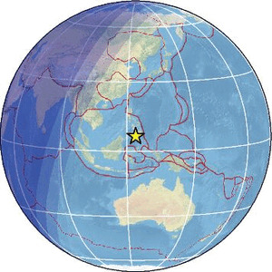
| Region | MORO GULF, MINDANAO, PHILIPPINES |
| Date time | 2026-01-20 23:25:17.8 UTC |
| Location | 6.430 ; 123.960 |
| Depth | 10 km |
| Distance | 94 km S of Cotabato, Philippines / pop: 179,000 / local time: 07:25:17.8 2026-01-21 17 km SSW of Kalamansig, Philippines / pop: 12,800 / local time: 07:25:17.8 2026-01-21 |
Source parameters provided by:
Geophysical Survey of the Russian Academy of Sciences -- Obninsk, Russia (GSRAS)
All data providers for this event:
Geoscience Australia, Canberra, ACT, Australia -- Canberra, Australia (AUST)Badan Meteorologi, Klimatologi dan Geofisika -- Jakarta, Indonesia (BMKG)
GeoForschungsZentrum (GFZ) -- Potsdam, Germany (GFZ)
Geophysical Survey of the Russian Academy of Sciences -- Obninsk, Russia (GSRAS)
Malaysian Meteorological Department -- Kuala Lumpur, Malaysia (MET)
Philippine Inst. of Volcanology and Seismology, Quezon City, Philippines -- Manila, Philippines (PIVS)
Further information can be found at:
Badan Meteorologi, Klimatologi dan Geofisika -- Jakarta, Indonesia (BMKG)Philippine Inst. of Volcanology and Seismology, Quezon City, Philippines -- Manila, Philippines (PIVS)
GeoForschungsZentrum (GFZ) -- Potsdam, Germany (GFZ)
National Earthquake Information Center, U.S. Geological Survey -- Golden, United States (NEIC)