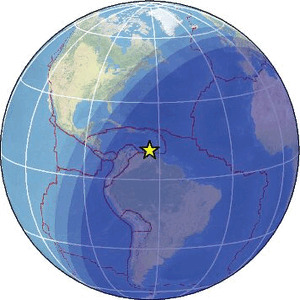
| Magnitude | 4.3 |
| Region | ISLA DE MARGARITA, VENEZUELA RG. |
| Date time | 2026-05-24 00:57:40.0 UTC |
| Location | 11.355 ; -63.926 |
| Depth | 10 km |
| Distance | 45 km NNW of Porlamar, Venezuela / pop: 216,000 / local time: 20:57:40.0 2026-05-23 38 km N of San Juan Bautista, Venezuela / pop: 90,300 / local time: 20:57:40.0 2026-05-23 |
Source parameters provided by:
University of the West Indies, St. Augustine, Trinidad -- Saint Augustine, Trinidad and Tobago (TRN)
All data providers for this event:
University of the West Indies, St. Augustine, Trinidad -- Saint Augustine, Trinidad and Tobago (TRN)Further information can be found at:
GeoForschungsZentrum (GFZ) -- Potsdam, Germany (GFZ)National Earthquake Information Center, U.S. Geological Survey -- Golden, United States (NEIC)
University of the West Indies, St. Augustine, Trinidad -- Saint Augustine, Trinidad and Tobago (TRN)